Check Out or Copy Out in ArcPad 8
In ArcPad 7.1, you had two choices when using the ArcPad Data Manager in ArcMap to prepare data for ArcPad, Check Out or Copy Out . Users then asked for some more options, so in ArcPad 8, you now get to be really specific about the data you Get for ArcPad.
The notion of 'Check Out' and 'Copy Out' still stands - 'Check Out' is for layers which you intend to edit in ArcPad, and then check those edits back into the Geodatabase. 'Copy Out' is for layers which you do not intend to check back into the Geodatabase, but you now get more options of how to work with them in ArcPad.
 Check Out
Choosing Check Out means that an single AXF file will be created for all selected vector layers and their related tables. These layers can be edited in ArcPad, and the edits can be checked back into the geodatabase. The AXF file created during check out contains data tables, feature tables, feature layers, forms, symbology, scripts, icons.
You can choose to check out each layer individually, or you can choose to check out all your layers by clicking on the 'Action' title bar
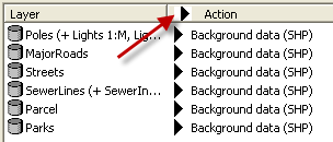
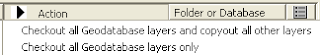
When you click the Action title bar you can choose to check out geodatabase layers, and either copy out all other layers, or leave the other layers behind.
REMEMBER: only geodatabase layers can be checked back in to ArcMap!
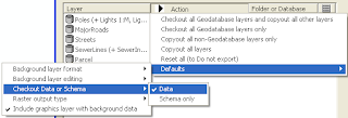
If you wish to Check Out 'Schema only' (ie: no data), you can set this as your default Check out setting. the Defaults for Check out and Copy out are all listed on the action menu.
 Copy Out
When choosing Copy Out, you have a few choices. The primary purpose of Copyed Out layers is for background information. Most typically, they are readonly and are only deployed to a mobile device to assist the user, not for data collection. A good example may be a contour layer. Contours are rarely edited, usually are big files, but are useful background data on a mobile device when working in rugged terrain.
Depending on your project needs, ArcPad 8 gives you the choice to Copy Out to read only or editable shapefiles OR AXF's. There are advantages and disadvantages to each of these - thats why you get to choose. Editing background data is not encouraged, but the capability to do so, has be supplied as a 'get out of jail' card for users. IF something is discovered in the field that should be recorded and brought back to the office, the user may be given the ability to capture that data, but it should be treated with special attention back in the office - rather than simply checking it in. ie: it may prompt the change of data collection procedures for future field work.
So which type of Copy Out do you choose?
Read only shapefiles are very fast to draw on low memory devices and are recommended for large vector layers used as background information eg: contour files or cadastre. Edits made to shapefiles can not be checked in to a geodatabase, BUT, users that have projects built on earlier versions of ArcPad may have procedures in place to process edits made in shapefiles. Choosing an editable shapefile for background layers is appropriate only for these projects.
Choosing a background AXF is good option for users that may have a lot of background layers. This minimises the number of files that need to be managed and deployed. The choice is available to make background AXF's editable, BUT these edits can not be checked in.
Copy Out is the only option available for raster layers, as these are not edited in ArcPad. If you have multiple raster layers to copy out (along with some vector layers to check out), it is recommended that you first ‘select all for copy out’ and then immediately click ‘select all for check out’. This will leave the raster layers selected and reselect the vector layers for check out rather than copy out.
The notion of 'Check Out' and 'Copy Out' still stands - 'Check Out' is for layers which you intend to edit in ArcPad, and then check those edits back into the Geodatabase. 'Copy Out' is for layers which you do not intend to check back into the Geodatabase, but you now get more options of how to work with them in ArcPad.
 Check Out
Choosing Check Out means that an single AXF file will be created for all selected vector layers and their related tables. These layers can be edited in ArcPad, and the edits can be checked back into the geodatabase. The AXF file created during check out contains data tables, feature tables, feature layers, forms, symbology, scripts, icons.
You can choose to check out each layer individually, or you can choose to check out all your layers by clicking on the 'Action' title bar
When you click the Action title bar you can choose to check out geodatabase layers, and either copy out all other layers, or leave the other layers behind.

REMEMBER: only geodatabase layers can be checked back in to ArcMap!
If you wish to Check Out 'Schema only' (ie: no data), you can set this as your default Check out setting. the Defaults for Check out and Copy out are all listed on the action menu.

 Copy Out
When choosing Copy Out, you have a few choices. The primary purpose of Copyed Out layers is for background information. Most typically, they are readonly and are only deployed to a mobile device to assist the user, not for data collection. A good example may be a contour layer. Contours are rarely edited, usually are big files, but are useful background data on a mobile device when working in rugged terrain.
Depending on your project needs, ArcPad 8 gives you the choice to Copy Out to read only or editable shapefiles OR AXF's. There are advantages and disadvantages to each of these - thats why you get to choose. Editing background data is not encouraged, but the capability to do so, has be supplied as a 'get out of jail' card for users. IF something is discovered in the field that should be recorded and brought back to the office, the user may be given the ability to capture that data, but it should be treated with special attention back in the office - rather than simply checking it in. ie: it may prompt the change of data collection procedures for future field work.
So which type of Copy Out do you choose?
Read only shapefiles are very fast to draw on low memory devices and are recommended for large vector layers used as background information eg: contour files or cadastre. Edits made to shapefiles can not be checked in to a geodatabase, BUT, users that have projects built on earlier versions of ArcPad may have procedures in place to process edits made in shapefiles. Choosing an editable shapefile for background layers is appropriate only for these projects.
Choosing a background AXF is good option for users that may have a lot of background layers. This minimises the number of files that need to be managed and deployed. The choice is available to make background AXF's editable, BUT these edits can not be checked in.
Copy Out is the only option available for raster layers, as these are not edited in ArcPad. If you have multiple raster layers to copy out (along with some vector layers to check out), it is recommended that you first ‘select all for copy out’ and then immediately click ‘select all for check out’. This will leave the raster layers selected and reselect the vector layers for check out rather than copy out.
posted by Marika @ 10:02
![]()
![]()


 News Feed (Atom)

<< Home