Your questions answered from the Field GIS Collecting and Editing Data Using ArcPad 10 Seminar
This blog entry contains both answered and unanswered questions submitted during the Live Training Seminar, which aired on November 18th. Questions that were asked multiple times have been consolidated and will only appear once here in this document. If you have any additional questions, please contact Esri Support by calling 1-800-377-4575 or by visiting the Online Support page. Thank you for participating in the seminar!
-Todd Stuber and Chad Minteer
Common Questions: http://www.esri.com/software/arcgis/arcpad/common-questions.html
1. How does ArcPad differ from ArcGIS Mobile?
The products differ in key areas, such as system requirements, typical workflows, and target audience. ArcPad is a map-centric field GIS software toolkit that primarily is used for disconnected editing (although it does also work with ArcGIS Server). Data is typically prepared on the desktop and checked out for ArcPad using the ArcPad Data Manager Toolbar in ArcMap (although there are geoprocessing tools for this also).
A good discussion of the comparison points can be found at http://www.esri.com/software/arcgis/about/mobile-gis-for-you.html as well as the “Common Questions” link above.
Typical workflows are discussed at http://resources.arcgis.com/content/arcpad/10.0/workflows.
2. What GPS receivers does ArcPad support?
This question is answered in the “Common Questions” area linked above. In addition to the receiver protocols listed there (including NMEA 0183, TSIP, etc.), ArcPad also supports SiRF receivers.
3. How is editing through ArcPad different from editing with an ArcGIS Server Feature Service?
The main difference is that editing in ArcPad can be done in a disconnected mode whereas a feature service requires that a real-time connection to the service.
4. Are there predefined templates for specific projects (that save me the work of customizing?)
The old ArcScripts area (www.esri.com/arcscripts) and the new Galleries area (http://resources.arcgis.com/gallery/file/arcpad) both have free template samples. Also, ArcGIS Online (www.arcgis.com) is a place to share and obtain geodatabase layer packages to help you build your geodatabase more quickly.
However, if you have a geodatabase already, you may just need to learn about the ArcPad Data Manager extension in ArcGIS for checking that data out for ArcPad.
5. Do I need a wireless connection to use ArcPad?
No. The only functionality requiring Internet connectivity is synchronization with ArcGIS Server and ArcGIS Online base maps (although these can be cached as well). All data collection and field GIS functionality can be done without a wireless connection.
6. Does ArcPad support Palm OS?
No. ArcPad supports Windows and Windows Mobile operating systems. See http://www.esri.com/software/arcgis/arcpad/system-requirements.html for a complete list of supported platforms.
7. Is ArcPad available in any language other than English?
Yes. A full list is provided in the “Common Questions” link above.
8. Are more ArcPad templates added on a regular basis?
Sample QuickProject templates are not added to ArcPad on a regular basis. But, new sample applications and data entry forms are regularly added to the Gallery at http://resources.arcgis.com/gallery/file/arcpad.
9. Which brands of laser rangefinders are supported by ArcPad? Are there any that are not supported?
ArcPad supports specific laser communication protocols. This ends up meaning that many commonly used brands and models are supported. A full list is proved in the “Common Questions” link above.
10. Do I need a GPS in order to use ArcPad?
No. ArcPad can be used to collect and edit data without GPS, although GPS is often used at least to provide an orientation on the map even if the primary data collection is attributes.
11. Is ArcPad 10 any faster than previous versions of ArcPad?
The answer to this loaded question depends. Hardware, operating system, memory, data, symbology, customization, extensions, and communication all play a part in the answer. But overall, yes, ArcPad 10 performs more efficiently and makes better use of available resources on mobile devices.
The ArcPad Help contains a Best Practices article on how to speed up map performance in ArcPad. This article can be found online at http://help.arcgis.com/en/arcpad/10.0/help/index.html#/How_to_make_your_map_draw_faster/00s1000000wm000000/.
12. Can ArcPad 10 connect to services that have been created in 9.3?
Yes.
13. How do I transfer an ArcMap file into ArcPad used in a GPS mobile unit?
The ArcPad Data Manager extension (or Trimble GPS Analyst extension, which uses the ArcPad Data Manager) is used to check data out for ArcPad, and the resulting data folder is copied to the device after connecting it via Microsoft ActiveSync (XP) or Windows Mobile Device Center (Vista or 7).
14. How do I differentially correct the data collected using ArcPad?
Data collected in ArcPad can be post-processed if the connected GPS receiver supports it, and you have installed an ArcPad extension to record the necessary information. For example, the Trimble GPScorrect extension for ArcPad records data for post-processing if a supported Trimble MGIS receiver is connected.
If ArcPad connects to GPS using NMEA or SiRF protocol, that data cannot typically be post-processed. However, depending on the GPS receiver, real-time differential correction may be available on the receiver itself. However, ArcPad cannot be used to configure real-time correction settings on the receiver, although it can filter data based on its real-time corrected status.
15. I need to know how to create a custom data entry form/template
There are several ways to accomplish this. The most common is to set up domains, required fields, and default values in the geodatabase in ArcGIS desktop. Then, use the ArcPad Data Manager to check data out for ArcPad. Data entry forms are created automatically when data is checked out.
To create custom data entry forms, or modify the forms that are automatically created, use ArcPad Studio (which installed on the desktop with ArcPad).
16. Have you ever created an .apm that appears to disable the ability of your gps to activate? If so how did you fix?
No, I have not observed that behavior, which in any case would be unexpected behavior. It would be best to submit a support incident to Esri Support using the Support Portal at http://support.esri.com/en/.
17. I understand ArcPad 10 can stream Bing Maps. Can those be cached onto the unit to bring to the field? Or can they be streamed from the field? How would that be done?
Generally speaking, online content can be cached using desktop tools (depending on license level and installed products). However, Microsoft licensing with Bing maps requires that ArcPad dispose its cache every 24 hours. If your field device has Internet capability (through cellular for example), then online base maps can be added directly into ArcPad on the mobile. However, this is not always possible or practical. Another approach is to build a base map for use in ArcPad. An example of how to accomplish this using a developer sample can be found on the ArcPad Team Blog at http://arcpadteam.blogspot.com/2010/08/create-local-map-tiles.html.
18. Is there an extension included for differential correction?
No extension is included. The Trimble GPScorrect extension can be purchased separately through Trimble distributors. Additional extensions for differential correction may be available for other receiver brands. Check with the GPS receiver manufacturer for more information.
19. What scripting language is used in Arc Studio?
VBScript and JScript for mobile devices. Python can also be used for desktop Windows. ArcPad acts as a hosted scripting environment, so the scripting host supported by the operating system dictates this.
20. I do not have ArcGIS Server, can I still use the base maps?
Yes. The online base maps demonstrated were from ArcGIS Online.
21. Do you need a wireless connection to add a sever base maps?
Yes.
22. How do you import a photo layer into ArcMap?
Third-party software tools such as Wind Image for ArcMap, GPS Photo Link, and Ricoh Data Manager (which is available with Ricoh GPS cameras) can process georeferenced photos and create point features in shapefiles or geodatabase feature classes.
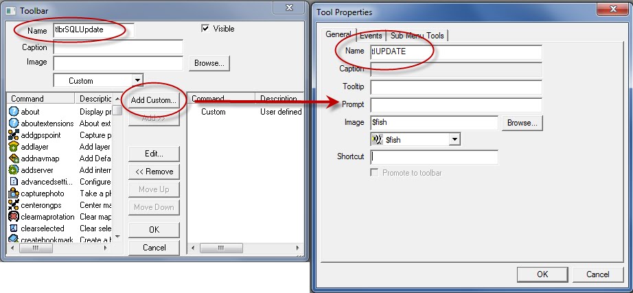
23. Can you make the Icons on Toolbars larger so they are easier to see on the field device?
Yes, this is a simple change in ArcPad. It’s kind of hard to find – it’s in Toolbar Options, which is accessible from the toolbar drop-down (tiny drop-down in grey toolbar area).
24. Where are photos saved for the photopoints? Are they saved on the SD card of the device?
The ArcPad photo layer can be created wherever you choose. Photos for the photo points are saved in that location.
Hyperlinked pictures are stored wherever the AXF file is stored.
Photos taken with the ArcPad camera button that are not part of a photo layer or linked to any features will be stored in the location specified in ArcPad Options.
25. I've noticed when checking out with ArcPad Data Manager in ArcGIS 10, the checkout at 'defined extent' kills ArcGIS 10. Is this a known problem?
This may be data-dependent. It would be best to submit a case to Esri Support to get to the bottom of it.
26. Are there any patches available for ArcPad 10?
Yes, ArcPad 10.0.1 (Service Pack 1) is available for download at http://resources.arcgis.com/content/patches-and-service-packs?fa=viewPatch&PID=26&MetaID=1709.
27. Are there any problems using ArcPad 10 with ArcGIS Desktop 9.3?
ArcPad 10 can be used with ArcGIS Desktop 9.3. The ArcPad Data Manager that is presented to the user on the desktop will be the same as what you’re used to with ArcPad 8. This only means that features of the ArcPad 10 Data Manager, such as Photo Fields, will not be available. Otherwise, AXF checkout and check-in will work as usual. Future Service Packs will only include fixes for the ArcPad 10 Data Manager however.
28. Will ArcPad be ported to the Windows Phone 7 device in the future?
Currently there are no plans to support this OS.
29. How accurate is GPS collection in ArcPad?
This depends entirely on the receiver used. Consumer GPS is typically 1-5 meter accuracy. Mapping or Utility grade GPS is typically sub-foot to 5 meter accuracy. ArcPad does support RTK, or survey-grade, GPS receivers, which are cm-level accuracy.
30. Can you link multiple pictures to one point? Is it possible to display the direction of photo taken in ArcPad if you have a camera that has the capability of storing that info?
Yes. This would require multiple photo fields, or a related table for attachments.
ArcPad does not support symbol rotation, so direction could not be indicated through symbology in ArcPad. Also, for cameras that have compasses built in, ArcPad does not have out-of-the-box capabilities to store that information as an attribute in a table.
31. How do I export a .img raster using ArcGIS 9.3.1 sp2 to ArcPad?
Use ArcGIS Desktop tools to convert it to a supported image format, or run it through the ArcPad Data Manager to convert to JPEG2000 format.
32. Will a large MrSID file work with ArcPad 10 on a Juno Trimble SB?
This depends. Large file sizes do tend to work well in ArcPad with a display scale set, so that the image is not displaying at all scales. However, speed and performance also depend on other factors, such as storage media, other map data (size, symbology).
The ArcPad Help contains a Best Practices article on how to speed up map performance in ArcPad. This article can be found online at http://help.arcgis.com/en/arcpad/10.0/help/index.html#/How_to_make_your_map_draw_faster/00s1000000wm000000/.
33. I have been using ArcPad for a while and don't see how to add time as well as date when a point is recorded. How do I do that?
Shapefiles don’t support Time fields, or Date/Time fields. Recording a time value in a text attribute requires scripting. Some samples are available on ArcScripts or Galleries.
34. Do you make changes to toolbars on the mobile unit or on the desktop version also?
The only toolbar that can be modified in the field is the Favorites toolbar. Toolbars can be hidden or displayed also. Otherwise, modifications are made using the ArcPad Toolbar Manager.
35. What is the major difference between ArcPad 7 vs. ArcPad 10?
The best answer to this is What’s New in ArcPad 10 (as well as What’s New in ArcPad 8). This can be found at http://www.esri.com/software/arcgis/arcpad/whats-new.html.
36. How many coordinates system does ArcPad supports. Is this number equal to ArcGIS 10?
ArcPad supports nearly every coordinate system that desktop ArcGIS does.
37. Is it possible to edit forms once they are created?
Yes. ArcPad Studio can be used to edit existing forms.
38. Can we do Linear Referencing with ArcPad? I work in gas and oil pipelines and need real-time stationing.
ArcPad currently does not support linear referencing; however, there are two enhancement requests in place asking that this be added to a future release:
CQ00125395: DATA Add: Add basic dynseg / linear referencing / measures for transportation market
CQ00168295: OBJ Add: Rudimentary Linear Referencing capabilities via OM
Please contact Esri Support if you wish to be added to these requests.
39. Is ArcPad 10 compatible with ArcGIS 9.3.1? Specifically, can I use the check-in check-out tools on the ArcPad toolbar?
Yes. The ArcPad toolbar can still be used to check out shapefiles, and ArcPad 10 can still use them. However, the ArcPad toolbar has been removed from ArcGIS 10. The ArcPad Data Manager is used instead.
40. Do you have to have the GPS correct and GPS analyst extensions to use ArcPad on Trimble units?
No. Trimble GPS receivers typically output NMEA, TSIP, or SiRF protocol. However, without GPScorrect and GPS Analyst (or Pathfinder Office), post-processing is not possible. Additionally, real-time correction and receiver settings control may require using Trimble GPS Controller, a free download from www.trimble.com/support.
41. Can you give more info on what RTK is and how to use it?
RTK (real-time kinematic) refers to survey-grade GPS equipment. ArcPad does not provide any tool s for controlling RTK receivers, but can connect to and use data from them if they output data in a supported protocol.
42. We have a Trimble Juno SB with a camera. Can this work directly with the photo layer option?
Yes.
43. The laser rangefinder provides a direction; how do you gain the azimuth or direction for the offset? With a lensatic compass? Does the software have magnetic declination data?
Most supported rangefinders measure at least distance and inclination angle. Some include a magnetic compass, so provide a bearing referenced to magnetic North. Correction to true North is accomplished by entering a magnetic declination on the laser, or in ArcPad (offset options).
44. Is there some type of correction with the camera? Photos of the object is not totally accurate.
There is no photo editing or image correction capability built in to ArcPad. Photo quality is completely dependent on the camera used.
45. When you have multiple people in the field editing the same database, how do you ensure that edits are not overwritten during the synchronization process?
This is a good question. The answer depends to some extent on the database that is used. For example, if checking data in and out directly to an SDE version, SDE provides tools for managing conflicts. In the case of personal or file geodatabases, the last edit wins, just as it does in desktop with multiple potential editors. In that case, potential conflicts are controlled by business process rather than software.
46. For someone that is transitioning from Pathfinder Office. What is equivalent to the .ddf data dictionary file? For instance in your last example with poles and lights and the sub options. Is that all created in QuickProject?
The equivalent to a data dictionary’s feature-attribute-attribute value taxonomy is a geodatabase feature class-domain-value. ArcCatalog is used to create a geodatabase with features, attributes (fields in attribute tables), default values, required attributes (allow null: false), domains (range domains for numeric fields, coded value domains for menu lists).
Training classes are available that cover all of this. See http://www.trimble.com/training.shtml to search for Trimble Certified Mobile GIS Trainers, all of whom teach ArcPad data collection workflows.
47. Can rangefinder locations be taken from an airplane or does it need to come from a fixed position?
Sure. The reference position for the laser measurement would be the GPS position at the time of the measurement.
48. Can a field be autonumber?
This would require scripting in ArcPad Studio.
49. Does ArcPad 10 support NULL numeric values? ArcPad 8 would automatically plug in a zero into the attribute table, which is a totally different thing.
Yes it does. The erroneous insertion of zeros for NULL values at ArcPad 8 was a bug (CQ00311122 – AXF Forms are showing NULL values as zero). This was fixed with the release of 10.
50. Are ArcPad Templates created using ArcPad Studio?
Studio is not required to create a template. Use ArcPad Data Manager to check out an AXF file along with an ArcPad map file called “Template.apm” then ZIP the data up and place it in the ArcPad Templates folder.
51. Can you add symbols to the quick capture tool bar?
You can use the Table of Contents to manage the contents of the Quick Capture toolbar. However, you can only add layers or categories that are already available. Symbol categories can only be defined in ArcMap and modified in ArcPad.
52. How is the bearing determined using the laser range finder?
Some range finders (Laser Technology TruPulse 360 for example) include a digital compass to measure the bearing. If not, bearing can be manually entered based on a compass measurement.
53. Can you create forms in ArcPad Studio using .axf files and related tables? Can you reuse forms if you modify the geodatabase?
Yes and yes. To reuse a form click the Layer Definition Template checkbox when checking the data out to assign an existing form to a particular layer.
54. Can the tables that we are seeing be made larger or wider? It seems to crowd a lot of text in dropdowns, etc.?
Yes, although this depends on screen size.
55. How does one get support for GPScorrect?
Support for GPScorrect can be obtained through Esri Support with a current ArcPad license, or through the Trimble dealer or business partner that you purchased GPScorrect. Paid support can also be obtained from Trimble Priority Support at (866) 560-6200.
56. Does ArcPad 10 run on Win7 x64?
Yes.
57. I have a custom toolbar from V8 without the quick capture shown on it. How do I quickly turn quick capture on/add it on the device.
The QuickCapture toolbar will display by default with an ArcPad.apx file created by ArcPad 10. If your toolbar is part of an applet that suppresses standard toolbars, the QuickCapture toolbar will display unless it is suppressed.
58. Does ArcPad10 allow me to split lines in the field?
No. If this is something you think ArcPad should do, please post your idea on http://ideas.arcgis.com.
59. Are there certain times of day when satellites work better and/or collecting data is better?
To some extent, yes. Trimble has a free Planning utility available at www.trimble.com/support (find Trimble Planning) that shows this information. Trimble GPScorrect also has a Plan section that shows the satellite coverage for the upcoming 12 hours.
60. Can you link directly from ArcPad 10 to your SDE server?
Yes. You can check data out from an SDE database/version, and back in. You can also synchronize ArcPad with ArcGIS Server using the ArcGIS Server ArcPad Extension.
61. Is there any place on the ERSI website that has lots of info on ArcPad? With examples and a technical manual?
Yes. The ArcPad Resources Page contains a lot of content, which is constantly updated.
ArcPad Product Landing Page: http://www.esri.com/software/arcgis/arcpad/index.html
ArcPad Resources Page: http://resources.arcgis.com/content/arcpad/10.0/about
Esri Support: http://www.esri.com/support
Esri Training: http://training.esri.com
62. I’m having trouble activating the GPS. I am using the Trimble Nomad. Settings? COM port?
Ensure the SiRF extension is enabled in ArcPad (Advanced Options > Extensions). The Nomad can output NMEA or SiRF. To reset the Nomad to NMEA output, bring up the power menu (hold power button) then Power Off. After turning the unit back on, it will output NMEA on COM2 at either 4800 or 9600 baud (depending on the model). In ArcPad GPS Preferences, use the Find GPS functionality (search or “binoculars” button) to search for the right COM port and baud.
63. Can you traverse to an area using a range finder (i.e. multiple reference points under canopy)?
Yes. Linear and radial traverses with laser rangefinders are supported in ArcPad.
64. Do you have to have a GPS enabled camera to hyperlink photos? Or do you just need Bluetooth capability?
To hyperlink photos, you need either a device with a built-in camera, or some way to get photos from the camera to the device. Some cameras can transfer via Bluetooth or WiFi. Also, Trimble TrimPix Pro software can be used with nearly any digital camera that has an SD card slot, and any device that has WiFi.
65. Does ArcPad 10 have logic capabilities within the forms design?
Sure. Whatever (il-) logic is supported by VBScript is supported in form design.
66. Can I check in and check out a geodatabase multiple times allowing me to see previously recorded information?
What you’re asking for sounds like archive versions in SDE. Check-in history is not preserved by the ArcPad Data Manager, so this would depend on other tools.
67. Is there any restriction on Personal vs. File geodatabases for checkout to axf?
No, not by design.
68. Is there a limitation of the update rate of the GPS position in ArcPad 10? If You are using a GPS device.
No, ArcPad does not impose a particular update rate. If the streaming interval is set to 1 in ArcPad, and the GPS receiver outputs at 10 Hz, then ArcPad will read and store at 10 Hz (depending of course on hardware and processing power).
69. Can you check out data into an .axf and provide it to multiple mobile units? Can you check out an additional .axf file before the data is checked in?
Yes. Checkout information is stored in the AXF file itself, so one checkout can be deployed to multiple field devices. Yes, additional checkouts can be performed before the first is checked in.
70. What types of geodatabases are needed for the 2 workflows?
Good question. Disconnected editing is supported by all geodatabases (personal, file, multi-user). ArcGIS Server with ArcPad Server extension requires the enterprise (SDE) geodatabase.
71. Can more than one mobile device update the GIS server at the same time under the GIS server work flow?
Of course; that’s the idea behind a service. Multiple synchronizations can occur simultaneously.
72. Can related tables in ArcPad 10 handle relationship classes related by Global ID? Such as source FC Global ID and a table GUID (also has own separate GlobalID) field relation in SDE. Had trouble in 10, worked in 8.
This should work; if not, please bring this to the attention of Esri Support.
73. Do you need an extension to ArcGIS Server to consume an editable map service in ArcPad?
No. But, in order to synchronize with Server, you would need the ArcPad Extension for ArcGIS Server.
74. Can multiple polygons be drawn as part of one record in the attributes?
No, ArcPad does not support multi-part polygon creation.
75. Is there an integrated tool which uses the distance from two known points to plot the intersection for the accurate plotting of an inaccessible feature when directional data is unavailable or of limited accuracy?
Yes. A 2-point offset can be entered. Enable Point Offset, and after the Offset form displays, switch to the 2-point offset form. Bearing-Bearing and Distance-Distance offsets are supported.
76. Can ArcPad 10 handle renaming the photos taken with the mobile device? "Tree_001.jpg" vs. "Photo_001.jpg"?
Yes to some extent. ArcPad Options has settings for renaming photos using a prefix (user-configurable) as well as Date/Time. Other options may be available via 3rd-party extensions to ArcPad.
77. Can you check out only queried data into an .axf file?
Yes. The final panel of the Get Data for ArcPad wizard allows you to check out only data that satisfies a definition query, only selected features, only the visible extent, and other options. So, you could run a query first, then check out.
78. What did you "uncheck" to be able to create points without answering attribute questions?
There is now an additional column of check-boxes in the Table of Contents to show or hide the edit form.
79. Can multiple users check out the same data from a database at the same time?
Yes, both multiple checkouts from the same database and a single checkout copied to multiple devices are supported.
80. Will ArcGIS ever be available for Android?
The ArcPad development team has not announced any plans as of yet.
81. Are there significant changes in ArcPad 10 since ArcPad 8?
Yes, there have been quite a few changes made to ArcPad since 8.0. The following link describes many of these changes: http://www.esri.com/software/arcgis/arcpad/whats-new.html
82. Is there a limit to the number of tool buttons/bars that can be used?
Technically no, there is no limit to adding tools to a toolbar. However, there will be a definite limit to how many tools will be visible on your screen at any given time so this needs to be taken into account.
83. Is the find tool still limited to 500 lines on the results tab?
No. If more than 500 records are returned, a dialog box will ask if you want to show all the records.
84. The buttons look bigger than in previous versions of ArcPad. Is this correct?
Yes, this is correct. The buttons got a new updated look at ArcPad 8.0.
85. Is there a preferred camera to use with the GPS unit?
Esri does not recommend one camera manufacturer over another, just that they meet system requirements. Please see the following link for supported digital cameras in ArcPad:
http://help.arcgis.com/en/arcpad/10.0/help/index.html#/Supported_digital_cameras/00s100000088000000/
86. Please give a quick summary of what it is that ArcPad Toolbar manager customizes?
The ArcPad Toolbar Manager allows you to create or modify a toolbar configuration file (e.g. ArcPad.apx etc.) without the need of ArcPad Studio. To launch the ArcPad Toolbar Manager, go to Start > All Programs > ArcGIS > ArcPad 10 > ArcPad Toolbar Manager.
87. How can I download the data from the desktop to the mobile device?
Data to use in ArcPad can be transferred to a mobile device from the desktop simply by copying and pasting it through either an ActiveSync (XP) or Mobile Device Center (Vista, 7) connection.
88. Is free ArcPad 10 license available with each ArcView 10 desktop license?
A free license of ArcPad does not come with ArcGIS Desktop. A full version of ArcPad is available for download on the ArcPad product page and can be used in 20 minute increments without a license.
89. How stable is ArcPad 10? We are new to it and hearing that it is having issues crashing... should we be worried?
No. ArcPad 10 is extremely stable and uses resources much more efficiently than its predecessors. If you do run into any issues please contact Esri Support. They will need to be looked at on a case-by-case basis.
90. Is it possible to cut and merge polygons in ArcPad 10?
No, ArcPad cannot split and merge polygons.
91. Can you use the toolbar manager in previous versions of ArcPad?
Yes. The Toolbar Manager was introduced at ArcPad 8.0, but can be used to edit configuration files (i.e. ArcPad.apx, ArcPadPrefs.apx, etc.) from earlier versions. Please note that any functionality that is introduced at the later release, cannot be added to a toolbar to be used in a previous release. For example, a toolbar that was created and currently used at ArcPad 8.0 can be edited using the ArcPad 10 toolbar manager. However, the QuickCapture tools cannot be added to that toolbar and used at 8.0.
92. Are there any problems or concerns with using ArcPad on a laptop only? I like to have more screen available.
There are no problems running ArcPad on a laptop instead of a mobile device. In fact there are some great advantages. One is the screen size you mention here. The other is the fact you can take advantage of the laptops higher processing power and storage capacity.
93. How or where do you set up the photo layer and associate it with the attribute information? For example we are collecting data on bluebird boxes and want to have images for the maintenance team to see what needs attention.
This is done in the last screen of the checkout process in ArcMap. You will associate which field will contain the hyperlinks to the images and which folder the images will be saved to once the data is checked back in. More details on how to incorporate photos into your workflow can be found here.
94. Can ArcPad 10 work with a 9.3.1 backend?
Yes, ArcPad 10 can be installed with ArcGIS 9.3.1, but it will revert to the 8.0 version of the Data manager Toolbar.
95. Has ESRI written a new book on using ArcPad 10 like they had for some of the older versions of this and other software? I have found these to be real valuable.
There is not a book published as of yet outside of the tutorials that come installed with ArcPad. This would be a good submission for the ArcGIS Ideas site.
96. Can I create survey forms for ArcPad so workers in the field can collect spatially referenced survey data?
Yes. Forms to collect this type of data can be created using ArcPad Studio.
97. Is it possible to use ArcPad in augmented reality environment?
No, ArcPad cannot be used in an augmented reality environment.
98. I used ArcPad 7.11 and tried to move up to ArcPad 8 but it worked very slowly on our GeoXH 2008 Trimble. Will this still be a problem with ArcPad 10?
Several performance enhancements were made to ArcPad 10 allowing it to run much more efficiently on mobile devices and take better advantage of the available resources. We have received a lot of positive feedback from users who have seen this boost in performance.
99. Without building a query statement, is there a way to look at the entire contents of feature table - and select individual record to pan to or edit the attributes?
This can be done using the Find tool.
100. Can the LaserTech be customized as well?
The LaserTech Rangefinder itself cannot be customized.
101. Does connecting a cell phone to do real time correction make a real difference with ArcPad 10?
Any kind of real-time corrections to the data to increase the accuracy of the positions is always a good thing! For example, The published specification for WAAS accuracy is approximately 5 meters horizontally, and 7.6 meters vertically. As a comparison, the published specification of the U.S. Coast Guard beacon system is 10 meters.
102. Does ArcPad have a tool or is there an extension available that creates random or systematically random (grid) points?
Unfortunately no there is not.
103. Can you set the view to automatically pan with the GPS location as center?
Yes. In the GPS Preferences window, check the box marked Automatically Pan View.
104. In the pole inspection example did you have to develop those data entry forms or does ArcPad already pre populate the forms, drop downs etc. based on the existing point file attributes?
The EditForms from the demos are generated automatically from the Data Manager Toolbar and the dropdowns are created when a field has a subtype or domain associated with it.
105. With Trimble GPScorrect will I be forced to operate out of a PGDB or is their functionality allowing me to work out of SDE?
GPScorrect currently only supports personal geodatabases. The suggested workflow, for those of you using SDE, is to create a replica database and work out of that. The changes made to the child replica can then be synchronized back to the parent database.
106. When editing multiple features, do you still have to highlight the pencil icon and choose the layer or can you just click on the quick capture tool.
The QuickCapture tool eliminates the need to click on the pencil icon to make a new layer editable. All you need to do is click on the symbol icon of the layer you wish to edit and it is automatically made editable.
107. How do you develop Quick project custom templates?
The ArcPad Team Blog has a great workflow, including a video posted on how to create custom templates.
108. Does ArcPad support collecting streaming data from an external sensor? This data would be from an RS-232 chip in a radiation detection instrument and updated every second.
Yes, ArcPad can do this by reading the data via the auxiliary serial port. You will most likely have to do some scripting in order for ArcPad to understand the incoming signal from the instrument.
109. How is it possible to judge if the GPS data is correct or are influenced by high buildings?
Check the skyplot window as you get closer to the buildings. If you start to see satellites drop out, you know that you are losing signal integrity. You can also monitor the PDOP values on the GPS Status ribbon on the screen. The higher the value, the more interference is being generated and the higher the possibility of a less accurate reading.
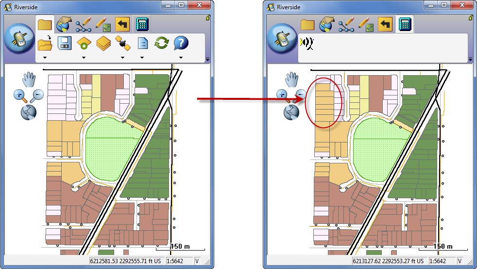
110. How do we get the quick capture tool tab to show up?
The QuickCapture tool is part of the default set of toolbars installed with ArcPad 10. It is the Pencil icon with the green checkbox next to it.
111. Is there a way of making the select symbol larger when we select a feature?
If you mean the highlighting around the symbol you are selecting, yes it can be made larger. In the Options window choose the Display tab. You will see the highlight option is set to a width of 3 pixels by default. You can change this value to something larger so it is easier to see.
112. Are QuickForms still available?
Yes they are. QuickForms are generated automatically upon checkout of the data.
113. Any plans to develop Arc Pad for iPad?
Not at this time.
114. What's the best way to update features mapped on daily bases, as an example..creating model builder, or get a replica geodatabase and use editing session?
Model Builder would be a great way of doing this. Most of the tools available on the Data manager toolbar are also available as geoprocessing tools in ArcPad Tools toolbox. These tools can be incorporated into a model which can then be run as an automated process. More information can be found here, including a link to a sample script.
115. We have had multiple issues checking data out to a network drive, and have had to work around checking out to a local drive and copying all the files. Have there been any solutions for this problem?
Yes. This bug, CQ00311502, has been fixed at ArcPad 10 SP1.
116. If you use the Data Manager to check out data which creates all your forms, etc., what workflow would you use to check this data back in using Trimble's GPS Analyst extension?
GPS Analyst will install it’s own toolbar in ArcMap. On the toolbar there are two buttons that can be added allowing a user to check data out to AXF format and back in. These buttons use the engine from the ArcPad Data manager and will create the same forms that ArcPad does. You can still check the data back in using the Check In ArcPad AXF File and GPScorrect SSF tool.
117. What versions of ArcPad work with ArcGIS Server 10.0?
ArcPad versions 8.0 and 10 are compatible with ArcGIS Server 10.
118. Can you provide any ArcGIS references on designing a network connection from internet to ArcGIS server located in a private network?
Resources for ArcGIS Server can be found here. If specific information regarding your network is not there, you can also contact Esri’s System Integration team by emailing them at sihelp@esri.com.
119. Is topology preserved through ArcPad edits?
No, ArcPad does not currently support topology.
120. Is the real-time processing as accurate as desktop post-processing?
Generally speaking, real-time differential correction tends to be slightly less accurate than post-processing.
121. To date we've been using shapefiles. In order to get the ArcPad 10 functionality, do we need to use geodatabases? i.e. can we use shapefiles? And if yes, what functionality will we lose?
You can still use shapefiles with ArcPad but there are limitations. For example, you cannot check out a shapefile for editing using the Data Manager toolbar; they can only be copied out as background reference data. The only way to edit shapefiles is to manually copy them onto the mobile unit, then copy them back to the computer after the edits have been made. Working from geodatabases is the recommended workflow.
You can still use shapefiles with ArcPad but there are limitations. For example, you cannot check out a shapefile for editing using the Data Manager toolbar; they can only be copied out as background reference data. The only way to edit shapefiles is to manually copy them onto the mobile unit, then copy them back to the computer after the edits have been made. Shapefiles also do not support domain information or date\time fields. Working from geodatabases is the recommended workflow.
122. Is there any minimum resolution requirement for using ArcPad 10 on handheld devices?
No, there is no minimum resolution requirement. For more details, please see the ArcPad 10 System Requirements page.
123. Is the functionality for moving pictures to a particular location only supported for photo point features or can it work for a feature class with photos added to an attribute?
This absolutely can be done for feature classes that wish to use a hyperlink to a photo stored as an attribute. The last screen of the Data Manager allows a user to designate which folder the photos will be moved to upon check in.
124. I just wanted to be clear that Arc Pad 10 is not compatible with ArcView 9.3?
ArcPad 10 is compatible with ArcGIS 9.3, however the 8.0 version of the data manager toolbar will be installed. See this blog entry for more details.
125. What are some differences or advantages between deploying ArcPad vs. ArcGIS Mobile
Some advantages of deploying ArcPad include the following:
- Editing existing geometry. If you make a mistake , you can go back and correct those mistakes at any time. This is particularly handy especially when you are 58 miles into a 125 mile stretch of collecting transmission line data.
- Creating data from scratch out in the field. ArcGIS Mobile does not have this capability.
- Support for related tables
- The use of laser rangefinders
- The ability, through the use of GPScorrect and GPS Analyst, to post-process data.
126. Can ArcPad 10 be used for survey line work i.e. projecting a line from a given point a distance and bearing?
Yes. The Linear Travers tool can be used for this.
127. Is there any list of compatible GPS devices that can synchronize with ArcPad 10? Is NMEA compliance the only way to figure out if a device would work with application?
ArcPad supports various GPs protocols so if your device can output to one of these, then it should be able to connect to ArcPad. Supported protocols include NMEA 0183, Earthmate, PLGR, SiRF, or TSIP.
128. How does the caching of ArcGIS online work? How much can be cached, how much space does it take up?
Caching works by breaking up the Basemap into individual tiles at different scale levels. This allows the software to stitch back only the information needed for a given area, saving time and process memory. There is not a limit on how much can be cached at one time except for the amount of physical memory you have free on your device at any given time. The space it takes up will vary depending on the area being cached and at what scale level.
129. Does ArcPad 10 and ArcGIS Mobile support post processing differential correction?
Neither ArcPad nor ArcGIS Mobile directly support post-processing. However, Trimble GPScorrect, an extension for ArcPad, writes satellite information to a file on the mobile device. These files then can be used by Trimble GPS Analyst, an extension for ArcGIS Desktop, for post-processing.
130. Does this customization employ VBA coding?
ArcPad uses VBscript and Jscript on the mobile device for customizations. Extensions for ArcPad can built using C++.
131. Do all hyperlinked photos have to be in the same folder on the Windows Mobile device?
Not necessarily. If you are associating existing photos to existing features then the photos can reside in multiple folders. If you are taking new photos then ArcPad will require you to choose a specific folder to save them to.
132. How do you install ArcPad on a second device?
Use the ArcPad Deployment Manager to install ArcPad to multiple devices.
133. Is there a list of bar code scanners that are compatible with ArcPad 10?
There is not. Some customization is needed in order to translate the data being sent from the barcode scanner to a format ArcPad can read.
134. Can you log carrier data in ArcPad 10?
ArcPad can log carrier and H-Star data via the GPScorrect extension.
135. I've had some trouble checking out deployments for ArcPad using the ArcPad Data Manager in ArcMap since v10 was released. Sometimes this causes ArcMap to shut down. Is there a way around this or an upcoming patch to correct this?
This is hard to pinpoint without more information. Your best bet would be to contact Esri Support to talk to an analyst.
136. How do you know if GPScorrect is installed on your device?
GPScorrect will install its own toolbar in ArcPad. You can also tap the Start > Programs to see if GPScorrect is listed
137. How can stakeout data be collected through ArcPad and what would the absolute accuracy of data/features be 3 dimensionally?
Stakeout data would be collected via a real-time kinematic (RTK) GPS link which can deliver sub-centimeter accuracy both horizontally and vertically.
138. Can ArcPad be extended with C#?
Yes, ArcPad functionality can be extended with C#.
139. Were the related tables’ part of a quick project? or part of geodatabase you transferred over via data manager?
The related tables used in the demos were part of a geodatabase and were checked out using the data manager toolbar. The forms were the default EditForms ArcPad generates upon checkout, no customizations were done.
140. How does real-time update work?
Real-time updates work by synchronizing ArcPad and ArcGIS Server via any internet connection.
141. Can a quick project be created on the mobile device, or only on the desktop?
QuickProjects can be created from scratch on the mobile device. See the ‘Getting Started with a new QuickProject’ section of the online help for more details.
142. We have units that are still running the ArcPad 7 & 8 platforms; are there also trainings available for those?
Some good documentation for ArcPad 7.1.1 can be found here. Be sure to also take a look at the QuickStart tutorials that come installed with the software as well. For more comprehensive training.
143. Can you suggest a virtual GPS device for testing the ArcPad - GPS workflow for a beginner?
ArcPad Studio 10 comes with a mobile device emulator allowing you to run a virtual mobile device for testing. Different types of mobile devices and operating systems can be downloaded from the Microsoft Download Center.
144. How would you use 'Move to GPS' with a laser rangefinder (i.e. an offset)?
The ‘Move to GPS’ function will move an existing vertex to the current GPS location. If you are using a rangefinder and need to move a vertex to the resulting offset, the workflow is slightly different. You would create the offset using the laser rangefinder first. This would give you the X and Y location. You would then use the Move To command and enter the X and Y location of the offset.
posted by Marika @ 13:10
![]()
![]()

.jpg)


 News Feed (Atom)
